| CUCC Home | ||
|---|---|---|
| Previous: Ten Years Under the Table |
CU 1973 Contents Page | Next: Expedition Diary |
Early in 1971, the Earby Pothole Club broke into what is probably the most important extension of the Easegill Caverns/Lancaster Hole system since the early fifties. The passages, which lead off from Stake Pot at Bob's Boss, range from old shattered fossil levels, which have obviously been deserted for many thousands of years, to young vadose trenches of beautifully sculptured limestone. A thorough description of most of the passages can be found in (1) but there still remains plenty of work to be done and the prospects of further new passage would seem to be extremely good.
It was after a trip into the extension in early December 1972 that our interest in the system began. This particular trip was curtailed due to partial flooding of the lower levels but we did manage to have a quick look at several promising, if a little shattered, inlets to the lower stream passage. This was enough to encourage us to attempt more serious pushing trips.
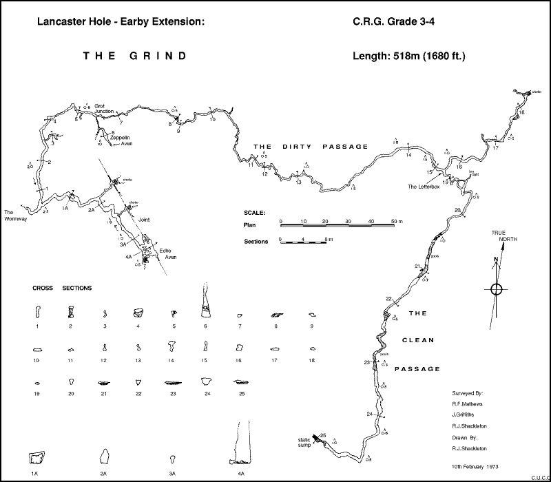
The obvious place to start the investigation was the Grind, a small muddy passage leading off from the Wormway about 60m before its termination at Echo Aven. The Grind was the only major portion of the whole extension which remained unsurveyed and it had not been pushed to a conclusion by the Earby in their initial explorations in 1971. It was on January 9th 1973 that Julian Griffiths and myself decided to have a good look at the passage, and to survey as much of it as possible in the time available. Surveying in the Grind is indeed a difficult task because of its awkward, constricted nature and its glutinous mud. It was rapidly found that the instruments became totally jammed up with filth, and so the surveying was shelved until a later date, when more man power would be available. However, two important things were achieved on this trip. The main passage was pushed to a conclusion, a static sump, and it was realised that, in its later stages, the passage could possibly be situated beneath Leck Fell and not Casterton, having passed beneath Easegill beck at some point along its length. This was later found to be true, and represents an interesting breakthrough in actual knowledge (as opposed to theory) of the hydrology of the Leck-Casterton cave systems; since the passage must have, at some time in the past, drained into the Leck Fell cave system.
Greatly inspired by the possibilities, a party consisting of Bob Mathews, Julian Griffiths and myself visited the passage again on 10th February 1973 with the intention of surveying the whole passage and assessing the prospects of bailing the static sump. The survey was completed without too much trouble, but it was clear that bailing the sump would be extremely difficult because of the chronic lack of "raw materials" in the vicinity of the sump to use for a dam. The conditions under which the survey was done were so bad that, in spite of our accurate equipment and careful readings, we feel that we can only claim CRG Grade 3-4 for the plan. THe clinometer readings were scrapped after only a short distance as it was found to be too difficult to keep the eyepieces on both the compass and clinometer free from mud at the same time. A copy of the survey is included for reference but it is by no means complete, as several important points remain to be cleared up. A description of the passage is useful at this point and although some of what is described has been accounted elsewhere it is nevertheless included here for completeness.
The Grind begins as a narrow inlet passage to the Wormway which takes a small trickle of water. The walls are covered with a thick layer of mud which is typical of all the lower passages of the Earby Extension as a whole, and it is this mud which characterises the whole of the initial part of the exploration. After passing a large blockage of mud and rocks under which it is necessary to crawl, a small inlet taking a tiny trickle of water is encountered on the right about 30m in. This is quite narrow and progress along it is only possible by sideways crawling about half way up the rift, it being too narrow at the bottom. Returning to the main passage, however, a second, smaller, side passage off to the right is met after a squeeze past a stal formation. This ends after a few metres of tight crawling in a silted choke, from which emerges a small flow of water.
The main source of water in the main passage is the low inlet off to the right at Grot Junction, about 10m past the stal. The water can be followed up-stream and after 5m of easy crawling the impressive 10m high Zeppelin Aven can be entered on the left, while a small quantity of water emerges from a choke on the right. The aven has been climbed but was found to be rather narrow at the top. The main way on from Grot Junction is to the left along a small ½m square passage liberally dosed with mud. The worst of the mud is passed after about 40m of flat out crawling where a squeeze over a boulder in the passage is met. Progress becomes a little easier until a small narrow passage on the left is seen and from then the main passage becomes narrower with sharp bends every 2m or so. The awkwardness persists for about 100m to a point where it is possible to stand up, and after a further 50m, a passage at shoulder level leads off through the Letterbox. The main passage continues for about 50m to a choke of boulders after passing a narrow inlet on the left. A way was forced through the boulders to a small passage beyond but the main way is still badly blocked at the present time.
Returning to the Letterbox, the Clean Passage leads off as a low crawl which passes an oxbow after 15m. The passage has two main points of interest. Firstly, it is completely free from any traces of mud except for those introduced by the explorers, and secondly it is not an inlet to the Dirty Passage as the flow markings on the roof and floor indicate that it is a totally separate downstream passage. Progress becomes easier after the oxbow, but the passage lowers again after an area of boulders, and several static pools with low airspace are reached. Having passed the pools, the passage opens up a little to a ½m high triangle before a second area of pools is encountered. Just before these pools is another region of boulders, this time of the rounded peaty variety commonly found in the streamways on the surface. It is curious to note that there is no apparent way by which these large rocks could have entered the passage from the upstream direction, as the entrance passage is too low. After the second area of pools the largest section of passage so far reached is encountered but after passing some interesting little helictites growing out of several calcite bands in the walls and floor, a static sump halts further immediate progress. Due to the absence of a draught in the passage, a sump had been expected but it was a little disappointing, after the increasing passage size had raised our hopes somewhat.
With reference to the survey several interesting points arise out of the course taken by the Grind. Firstly, when matched with existing surveys of both Lancaster Hole and Pippikin Hole the passage can be seen to pass beneath the Easegill beck and to terminate within 50 feet horizontally of the surveyed end of the Dickery's Inlet of Pippikin Hole. Secondly, the Clean Passage, which is phreatic in its origin, must have, at one time, carried water from sinks actually on Casterton Fell into the Leck Fell drainage system, as there is no plausible connection with any possible water supply from Easegill beck itself. The passage seems to be remarkably free from the effects of the supposed main joint direction NW-SE referred to somewhat innacurately in (2), in connection with the development of Pippikin Hole. An example of such a joint would be the one linking Echo Aven and the choked inlets to the Wormway on the survey. The Clean Passage is, for 90% of its length, travelling at almost right angles to this joint direction, but no sign of any effects can be seen in the passage itself, save for the thin calcite bands which cross the passage near the sump.
Dealing with the first of the above, Roger Wilbourne and I visited the Dickerys on February 17th 1973 in order to find just how the passage does end. With little knowledge of the relative heights of the Dickerys and the Clean Passage, it was clearly necessary to find out how the Dickerys ended and what the passage looked like to see if a link could be feasible. Three observations were made on this trip. Firstly, that the character of the Dickerys in its later stages is very similar to the Clean Passage. Secondly, the Dickerys ends in a low constricted inlet sump supplying a small trickle of water. Thirdly, that a little mental arithmetic based on the vertical separation of The Hobbit and Echo Aven, and on clinometer readings taken in the Grind and The Dickerys, indicated that the two passages should end within about 2m vertically of each other.
These observations are both encouraging and disconcerting at the same time; whilst the similarity in character of the two passages suggests a connection, the question of where the excess water comes from is awkward, as more water flows out of the sump in the Dickerys than the minute quantity which is supplied by the Clean Passage. This problem could be resolved by hypothesising an inlet actually in the sump but this awaits factual proof. The immediate course of action is obviously to attempt to bail from the downstream end of the sump but the passage is so small that this will be extremely difficult. Also, it should be taken into account that any airspace that is created could rapidly fill up due to the flow out at the downstrem end. However, this remains a project for the near future and will probably have been attempted before this article goes to print.
A connection between these two major systems would certainly be quite an achievement, and it certainly looks as if a link is quite close. A through trip by this route would certainly be quite an epic involving at least half a mile of almost all flat out crawling between the Wormway and Redwall Chamber, the bailing of a sump in the middle (as free diving looks to be out of the question), and two miles of difficult passage to traverse at the Lancaster Hole end.
In spite of these exciting "possibilities", the mapping and completing of the exploration of the Grind does represent a significant advancement of our knowledge of the relationship of the caves beneath Leck and Casterton Fells, and it is hoped that continued activity in the future will provide more interesting information to add to the overall picture.
(1) ULSA Review 9 pp. 3-11
(2) ULSA Review 9 p. 17
| The conclusion to this work was later described in Cambridge Underground 1975 | ||
|---|---|---|
| CUCC Home | ||
| Previous: Ten Years Under the Table |
CU 1973 Contents Page | Next: Expedition Diary |